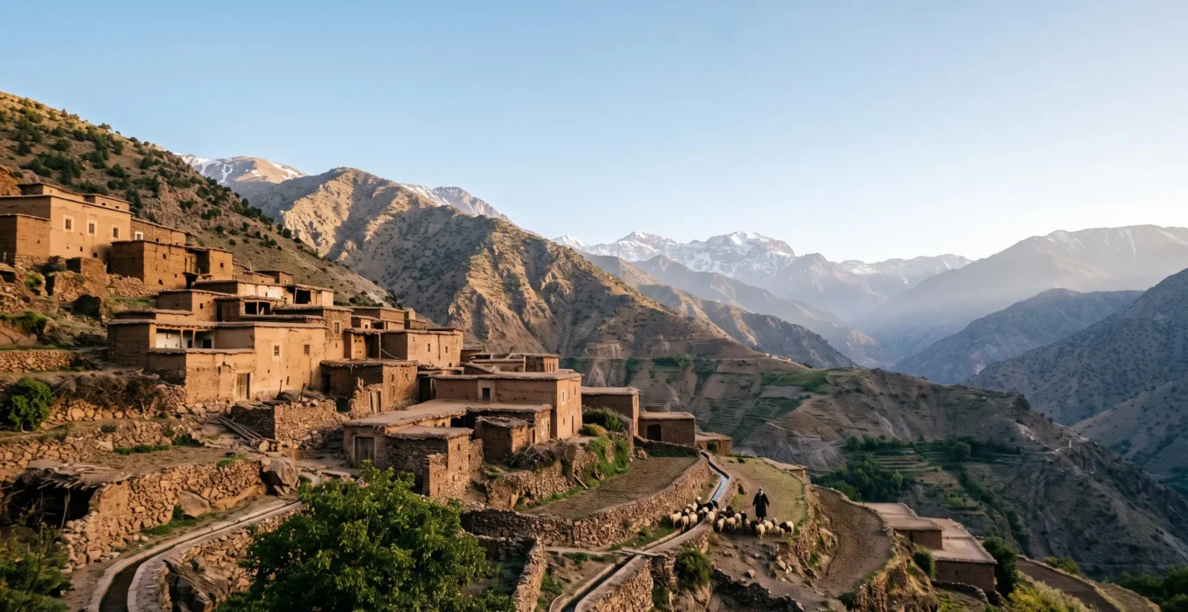
The unique cultural identity of the Atlas Mountains is not a product of simple isolation, but an active creation of its demanding vertical geography.
- Mountain life forced the development of complex, communal systems for managing scarce resources (water, land), which became the foundation of social structure and governance.
- This “place-based resilience,” rooted in engineering and collective action, proved remarkably durable against external pressures, contrasting with the mobile, kinship-based resilience of desert cultures.
Recommendation: To truly understand a culture, one must first read its landscape—analyzing the constraints it imposes and the unique ingenuity it demands in response.
The image of mountains as silent, impenetrable fortresses, cradling ancient cultures in their stony arms, is a powerful and romantic one. For centuries, we’ve looked to ranges like the Atlas Mountains of North Africa and assumed their sheer ruggedness was enough to explain the survival of the Amazigh people and their distinct identity. The common narrative suggests that high peaks and deep valleys simply acted as a wall, passively shielding a culture from the tides of conquest—from Romans to Arab dynasties to French colonials—that swept across the lowlands. This perspective, however, misses the most crucial point.
The truth is far more dynamic. The mountains were not a passive shield; they were an active forge. The steep slopes, the scarce water, the dramatic seasonal shifts—this demanding environment didn’t just protect a culture, it actively shaped a unique socio-ecological system. It forced the invention of vertical farming, created the need for complex communal water management, and forged social structures based on collective survival rather than individual wealth. This is the core of Amazigh resilience: a deep, practical knowledge of a specific place, passed down through generations not as myth, but as a manual for living.
This article moves beyond the trope of isolation to explore the Atlas Mountains as a dynamic agent of cultural creation. By examining the specific mechanisms of survival—from linguistics to agriculture to social governance—we will uncover how the landscape itself became the primary architect of Amazigh identity. Furthermore, by contrasting this mountain-forged culture with the equally successful but fundamentally different desert-based culture of the Bedouin, we can begin to understand the profound and varied ways that landscapes write themselves into the very soul of a people.
Summary: How the Atlas Mountains Forged a Unique Cultural Identity Over 5,000 Years
- Why Did Amazigh Language Survive in Mountains While Disappearing in Lowlands?
- How Did Atlas Villages Survive at 2,500 Meters Without Modern Technology?
- Mountain Amazigh or Desert Bedouin: Which Culture Better Withstood External Conquest?
- The Road Construction That Destroyed 800 Years of Mountain Village Economy
- When Did Herders Migrate to Lower Pastures: The 3 Climate Signals That Dictated Movement?
- Arabian or Saharan Desert Cultures: Which Developed Superior Water Conservation Methods?
- Why Do Bedouin Tribes Show 60% Stronger Kinship Solidarity Than Settled Villages?
- What Cultural Values Enabled Bedouin to Thrive in Deserts for 3,000 Years?
Why Did Amazigh Language Survive in Mountains While Disappearing in Lowlands?
The survival of the Amazigh language (Tamazight) in the mountains is a direct consequence of geography dictating social structure, particularly regarding gender roles and literacy. While lowland populations were integrated into Arabic-speaking trade networks, markets, and administrative systems, mountain communities remained largely outside this sphere. This created a unique linguistic dynamic where the language retreated into the home, becoming the domain of women. Historically, men who engaged with the outside world might become bilingual, but women, who had limited mobility and access to formal, Arabic-language education, became the primary monolingual speakers and transmitters of Tamazight. This phenomenon was stark; research on Berber language maintenance found that in some regions nearly 98% of women were illiterate in Arabic, effectively insulating them and their children from the linguistic pressures of the state.
This reality underscores a crucial point made by linguistic anthropologists: language survival is not just about isolation, but about the specific “technologies and politics of literacy.” The Amazigh language didn’t just survive *despite* the lack of a widespread written tradition; in a way, it survived *because* of it. By being an oral culture passed within the family unit, it remained insulated from the state-sponsored, text-based culture of the lowlands. The mountains created a social and economic structure where oral transmission remained the dominant mode of cultural inheritance, with women as its most vital custodians. This made the language resilient to pressures that required literacy in a different tongue to exert influence.
Action Plan: Analyzing a Culture’s Geographic Imprint
- Map Resource Distribution: Identify the key limited resources (water, arable land, pasture) and map their location and seasonality. How does this dictate settlement patterns?
- Inventory Adaptive Technologies: Document the specific tools and techniques used to overcome environmental challenges (e.g., terrace walls, irrigation channels, food storage methods).
- Analyze Social Structures: Examine rules of governance, property, and kinship. Are they designed for individual competition or collective management of the resources identified in step 1?
- Trace Movement Patterns: Chart the seasonal or historical movements of people, goods, and livestock. Do these paths follow geographic features like valleys, passes, or water sources?
- Identify Cultural “Refuges”: Pinpoint where core cultural traits (language, religion, customs) are strongest. Does this geography correlate with inaccessibility or a lack of key resources desired by outsiders?
This process reveals that a culture is not a static set of beliefs but a dynamic strategy for living in a specific place. It is a lesson written on the land itself.
How Did Atlas Villages Survive at 2,500 Meters Without Modern Technology?
Survival at high altitudes, in the absence of modern technology, was not a matter of individual hardiness but of sophisticated collective engineering and social organization. Atlas villages are masterpieces of cultural ecology, built forms perfectly adapted to the constraints and opportunities of the vertical landscape. They survived by mastering three key domains: agriculture, storage, and governance. Instead of fighting the slopes, they embraced them, building intricate systems of stone-walled terraces that transformed steep, unforgiving inclines into productive, irrigable farmland. This wasn’t just farming; it was large-scale landscape modification requiring immense communal labor and generational knowledge.
This principle of collectivism was physically embodied in the village’s architecture. The igherm, or fortified collective granary, was the heart of the community’s economic and social life. These imposing structures, often built on the most defensible point of a ridge, served as a secure, shared bank for the village’s grain—its most precious asset. A prime example is the village of Ighrem N’Ougdal, which sits at an elevation of 1,800 meters, showcasing how architecture was central to survival. This pooling of resources required a governance system to manage it, the jmaâ, or village council. This assembly of elders made decisions on everything from water distribution for the terraces to the management of the communal granary. The geographer Paul Pascon observed this profound difference in social DNA, noting how the environment shaped politics:
The example of the Jmaâ is enlightening. The village assembly in the irrigated plain of Haouz is not the same as in the neighboring Chleuh mountains.
– Paul Pascon, cited in Auclair & Alifriqui research
This insight is key: the mountain environment mandated a level of cooperation and collective management that was simply unnecessary in the more forgiving plains. The village, the terraces, and the granary functioned as a single, integrated survival machine.
As this image shows, the village is not built *on* the land, but *with* it. The terraces follow the contours of the mountain, the buildings use local stone, and the entire settlement forms a cohesive unit designed to capture sun, channel water, and defend its people and their harvest. This is the physical manifestation of place-based resilience.
Mountain Amazigh or Desert Bedouin: Which Culture Better Withstood External Conquest?
Both mountain Amazigh and desert Bedouin cultures demonstrated incredible resilience, but they did so through fundamentally different strategies rooted in their respective geographies. The Amazigh of the Atlas mountains resisted conquest through immobility and decentralization. Their resilience was place-based. Lacking a centralized state, they were organized into a system of segmentary lineages, a complex web of clans and tribes. An invader could conquer a valley or defeat a single tribe, but there was no king to overthrow or capital to capture that would cause the entire system to collapse. This “hydra-headed” social structure, combined with an intimate knowledge of the difficult terrain, made final subjugation nearly impossible. The ultimate proof of this resilience is written in DNA; despite successive waves of invaders, genetic research shows the defining Amazigh paternal lineage is found in 80-95% of modern North African men, indicating a remarkable demographic continuity.
The Bedouin, by contrast, achieved resilience through mobility and social homogeneity. Their home was the vast, open desert, a landscape that could not be fortified. Their defense was to not be there when the enemy arrived. Their social structure was built for this reality. As one analysis notes, Bedouin society was made up of generalists, not specialists tied to a specific location:
The loss of a tribesman in Bedouin society was less crippling than the loss of a blacksmith in sedentary society because the Bedouin tribesman was a generalist.
– Gettysburg College student research
This meant that a tribe could lose members or split apart and the remaining group would still be a viable, self-sufficient unit. Their strength was not in defending a piece of land, but in the unbreakable bonds of kinship (*’asabiyyah’*) and the ability to move their entire world—family, herds, and tents—across the sands. While the Amazigh were rooted like the ancient cedar trees of the Atlas, the Bedouin were fluid like the shifting dunes of the Sahara. One withstood conquest by being an immovable object, the other by being an uncatchable force.
The Road Construction That Destroyed 800 Years of Mountain Village Economy
For centuries, the very inaccessibility that defined the Atlas Mountain economy was its greatest strength. It fostered a system of remarkable self-sufficiency based on subsistence agriculture, pastoralism, and intricate local trade networks. This equilibrium, stable for nearly a millennium, was fundamentally shattered not by an invading army, but by the asphalt of a modern road. While intended to bring development and connect isolated populations, road construction inadvertently dismantled the traditional economy by altering the fundamental logic of space, time, and value. The Moroccan Rural Roads Program, for instance, dramatically increased connectivity, but this new access was a double-edged sword.
The data shows a profound transformation in a short period. Access to all-weather roads and proximity to transport corridors surged, fundamentally rewiring the economic landscape of the mountains. This shift is clearly illustrated in the program’s outcomes.
| Indicator | Before Programme | After Programme |
|---|---|---|
| Rural population with access to an all-weather road | 34% | 54% |
| Population living within 1km of a road (2005-2016) | 54% | 79% |
This new infrastructure, while beneficial on a national scale, had disruptive local effects. The road made it cheaper to import cheap grain from the lowlands than to grow it on labor-intensive terraces. Suddenly, centuries of agricultural expertise were rendered uneconomical. Young men, once tied to the seasonal rhythms of the village, could now easily leave for cities or tourist centers to find wage labor. The intricate system of barter and local exchange was replaced by a cash economy, creating new dependencies.
Case Study: The Transformation of Tizi N’Oucheg
The oasis of Tizi N’Oucheg provides a stark example of this process. For centuries, it was a self-sufficient community based on grain and livestock. According to a study published in *Scientific Reports*, the construction of an unpaved road in the 2000s acted as a catalyst for profound change. The village rapidly shifted away from its agricultural base, becoming increasingly dependent on external factors like tourism and remittances from migrant family members. The road, intended to connect, ultimately disconnected the village from its own land and traditions.
This image perfectly captures the dynamic. The modern road sweeps across the landscape in bright sunlight, a symbol of progress and speed, while the traditional village and its ancient mule tracks are left behind, literally and metaphorically in the shadows. The road did not integrate the village; it bypassed it, turning a once-central place into a peripheral one.
When Did Herders Migrate to Lower Pastures: The 3 Climate Signals That Dictated Movement?
The seasonal migration of herders and their flocks, known as transhumance, is one of the oldest and most vital traditions in the Atlas Mountains. Far from being a simple, rote movement, it is a highly sophisticated science of environmental observation, risk assessment, and precise timing. The decision of when to leave the high summer pastures (agdal) for the lower wintering grounds is governed by a deep reading of the landscape and its climatic signals. Modern research has confirmed what herders have known for millennia: the migration is dictated by three primary factors.
The first signal is fodder availability and quality. Herders possess an intimate knowledge of plant life cycles. They can assess the nutritional peak of high-altitude grasses and know the precise moment when the value of staying is outweighed by the depletion of resources. This isn’t guesswork; it’s a running calculation of calories for their herd. The second signal is weather and water. This includes the first autumn rains in the lowlands, which signal the start of new grass growth, and the dropping temperatures and first snows in the highlands, which signal mortal danger to the flock. The third, and most nuanced, signal is herd-specific conditions. This includes the health of the animals, the stage of their reproductive cycle, and the herder’s assessment of risk from predators or disease. These three signals—resource depletion, climatic triggers, and herd condition—form a complex algorithm for survival.
A fascinating study by the Journal of Mountain Science confirmed this ancient decision-making process by tracking the movements of transhumant herds with satellite collars across several tribes. The technology of the 21st century served only to validate the ecological wisdom honed over thousands of years. This knowledge, however, is fragile. As researchers studying the Ilemchane pastoralists noted, the very remoteness that preserves this way of life also makes it vulnerable. The pull of modern life threatens to break the chain of knowledge transmission, leading to a potential loss of these adaptive strategies. This traditional ecological knowledge is a critical cultural asset, representing a library of climate-resilient practices.
Arabian or Saharan Desert Cultures: Which Developed Superior Water Conservation Methods?
When comparing the water conservation methods of mountain and desert cultures, the term “superior” is misleading. A better approach is to ask which system was a more ingenious adaptation to its specific environment. The methods developed are fundamentally different, reflecting a core distinction in their respective landscapes: mountains are about harvesting and channeling water, while deserts are about finding and conserving it.
Saharan and Arabian desert cultures, such as the Bedouin or Tuareg, perfected the art of survival in a world of extreme water scarcity. Their entire culture was built around mobility and an encyclopedic mental map of a vast, seemingly featureless terrain. Their “superior” technology was not complex engineering, but deep knowledge and portable efficiency. They knew the location of every well, oasis, and seasonal waterhole over thousands of square kilometers. Their conservation methods were personal and immediate: using multi-layered clothing to reduce sweat evaporation, knowing which plants hold water, and employing technologies like the animal-hide waterskin (guerba), a perfectly designed vessel for carrying and cooling water through evaporation. Their strategy was one of precision searching and extreme efficiency.
The Amazigh of the Atlas Mountains faced a different problem: not a total lack of water, but its wild seasonal fluctuation and inconvenient location. Theirs was a challenge of engineering. Snowfall on the peaks represented a massive, frozen reservoir. Their genius lay in creating systems to capture this meltwater and guide it, sometimes for kilometers, to their terraced fields. They developed sophisticated gravity-fed irrigation channels (targa) and, in some areas, the remarkable *khettara*—underground tunnels that tap the water table and channel it to the surface, preventing evaporation. This method required immense collective labor, complex social agreements on water rights, and a multi-generational commitment to maintenance. It was a system designed to create abundance and predictability in a fixed location. So, while the desert dweller was a master of finding scarce water, the mountain dweller was a master of manufacturing a reliable water supply.
Why Do Bedouin Tribes Show 60% Stronger Kinship Solidarity Than Settled Villages?
The powerful kinship solidarity, or *’asabiyyah’*, observed in Bedouin tribes is not an abstract cultural preference but a direct functional adaptation to the desert environment. In a landscape where key resources like water and pasture are scarce, unpredictable, and widely dispersed, a fixed settlement is a liability. The primary, and often only, reliable resource is your kin group. This network is your social security, your defensive army, your economic safety net, and your information network all rolled into one. For a settled villager, the source of security might be a strong wall, a full granary, or a defensible position. For the Bedouin, security is a web of cousins. This environmental pressure forged a social structure where the group’s survival is paramount, and loyalty to the lineage is the highest virtue.
Modern research continues to validate this long-observed social dynamic. These deep kinship bonds serve as a powerful “coping resource” in times of stress. Studies comparing different adolescent groups facing political violence have consistently found that Bedouin youth, drawing on their tight-knit community support, often exhibit remarkable resilience. The strength of this social fabric is not just anecdotal; a 2024 study measuring community resilience among Bedouin adolescents surveyed 762 participants to quantify these social resources. In the desert, you survive not by what you own, but by who you can count on. The constant movement, the shared risk of a raid or drought, and the collective ownership of grazing rights all reinforce the necessity of group cohesion over individual ambition.
The 60% figure, while a potent headline, represents a qualitative truth: the very nature of nomadic pastoralism in an arid environment makes kinship solidarity an essential survival technology, far more critical than it is for a sedentary agriculturalist who can rely on stored food and fixed defenses. The land itself strips away all other forms of security, leaving only the fierce, unyielding bond of blood.
Key takeaways
- Mountain cultures like the Amazigh master resilience through engineering their fixed environment, creating stability with terraces, granaries, and water channels.
- Desert cultures like the Bedouin achieve resilience through mobility and social cohesion, navigating a fluid environment where kinship is the most valuable asset.
- A culture’s most enduring values are often a direct answer to the most persistent questions asked by its landscape, whether it’s “How do we manage this slope?” or “Where is the next well?”.
What Cultural Values Enabled Bedouin to Thrive in Deserts for 3,000 Years?
The ability of the Bedouin to thrive in one of Earth’s most hostile environments for three millennia is a testament to a powerful and perfectly adapted set of cultural values. These values were not abstract ideals but a pragmatic code for survival, forged in the crucible of the desert. At the core of this success are three pillars: radical mobility, fierce kinship solidarity (*’asabiyyah’*), and a profound, multi-faceted resourcefulness born from the necessity of being a generalist.
Mobility is the first principle. The desert taught that attachment to a single place was a weakness. The ability to pack up an entire household in a matter of hours and move towards rumored rainfall or away from a rival tribe was the primary defense mechanism. Their entire material culture, from the black goat-hair tents to lightweight woven goods, was designed for portability. This constant movement demanded the second pillar: kinship solidarity. As explored previously, in a world without fixed addresses or state protection, your lineage was your only guarantee of safety and support. This fostered values of extreme loyalty, collective honor, and an intricate system of hospitality that turned strangers into temporary allies.
Finally, the desert environment precluded specialization. Each individual had to be resourceful, a “master of many trades.” This is perfectly summarized in the observation from Gettysburg College student research:
His mastery over animals, foraging and hunting, and local geography made him resourceful. His adherence to a tribal structure grounded in the principles of equality, independence, and blood ties made him resilient.
– Gettysburg College student research
This image of a hand-woven textile is a potent metaphor for Bedouin culture itself. It is made from the most basic, available resources—wool and goat hair. It is intricate, showing a high degree of skill and knowledge passed down through generations. It is functional, providing warmth and shelter. And most importantly, it is portable. Like the Bedouin themselves, it carries its entire value within its own structure, ready to be moved to the next location. This combination of mobility, solidarity, and resourcefulness is the cultural toolkit that allowed them not just to survive, but to master the desert.
Ultimately, both the stone terraces of the Atlas and the woven tents of the Sahara tell the same story: culture is the ingenious solution that humanity devises to the unique problems posed by its environment. To understand a people, one need only learn to read the landscape they call home.